Know what’s happening in the oilfield — before the competition
Wellsite™ uses AI-powered intelligence to give oil & gas professionals early visibility into drilling, completion, and production activity before it becomes public knowledge.
What is Wellsite™?
Wellsite is an AI-powered data analytics platform with a twist — instead of static dashboards, it delivers a real-time, noise-free activity feed of verified industry intelligence, personalized to your business.
Wellsite tracks every stage of the well lifecycle — so you don't have to
Get real-time alerts, see what’s happening in the field, and act faster with AI-powered insights.
Drilling
Detect pad construction, track rig activity, and forecast spud dates using early signals from satellite imagery, public filings, and crowdsourced inputs—enhanced with AI.
Completions
Follow frac crew movement, spot when wells enter the fracturing stage, and anticipate flowback with real-time signals tied to completions milestones.
Production
Monitor first production timing, identify which wells are being brought online fastest, and track where DUC inventory is being drawn down or built up.
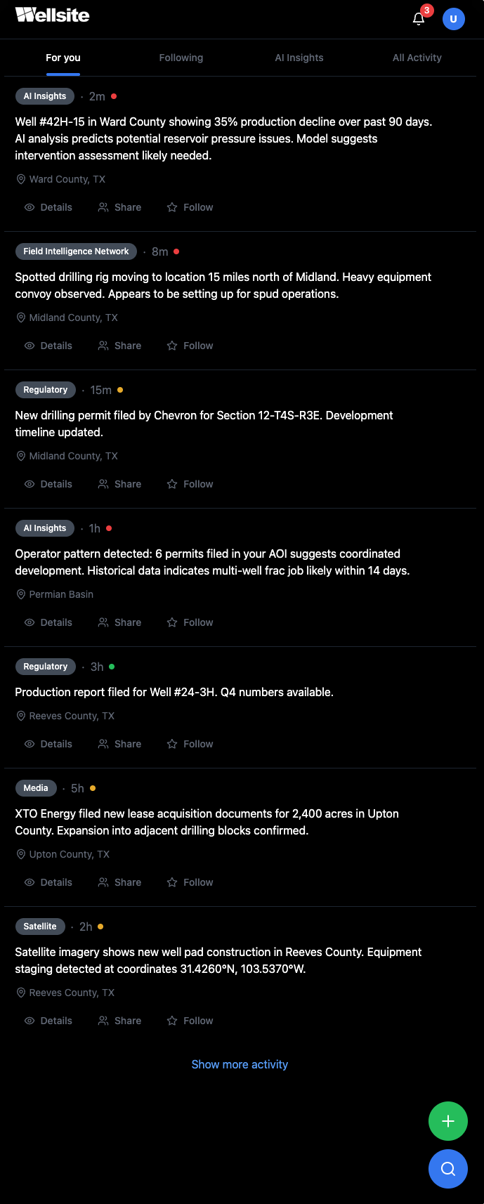
See oilfield activity as it happens
Wellsite delivers real-time, verified updates powered by AI, automated data ingestion, and trusted field intelligence — not random posts or influencer chatter. Every update is matched to your locations, companies, wells, activity types, and (in Enterprise plans) your team.
The result:
Signal, not noise — every post has value.
Always-on awareness — the platform works 24/7 so you don’t have to.
Effortless curation — set your preferences once, and Wellsite keeps you ahead of the curve.
Collaborate without the clutter
In Enterprise, authorized team members can post private updates that appear right alongside AI and field intelligence events — visible only to your team. This keeps your feed relevant, actionable, and aligned to your operations.
Why oil and gas professionals choose Wellsite
Get early market intelligence
Stop reacting to yesterday's news. Wellsite combines satellite imagery, public records, and machine learning to spot oilfield activity before it hits official reports, giving you the intelligence advantage to act while opportunities are still available.
Turn data into opportunity
Wellsite transforms scattered operational signals into clear, actionable insights that help you identify the best opportunities, deploy resources where they'll have the biggest impact, and make confident decisions based on real-time market intelligence.
Simplifies intelligence gathering
Replace time-intensive manual monitoring with automated intelligence collection. Wellsite's AI continuously scans multiple data sources—from satellite imagery to permit filings—so your team can focus on analysis and action rather than hunting for scattered information across dozens of sources.
Stay ahead of the competition
Wellsite delivers real-time insights that let you spot trends, track competitor moves, and identify emerging opportunities before they become common knowledge. Get the intelligence edge that transforms how you make strategic decisions in the energy sector.
Get oilfield intelligence faster
See drilling activity, permits, and equipment movements in one real-time feed—so you can act on opportunities while others are still searching scattered sources.
Frequently Asked Questions
What is Wellsite?
Wellsite is an AI-powered data analytics platform with a twist — instead of static dashboards, it delivers a real-time, noise-free activity feed of verified industry intelligence, personalized to your business.
How does it work?
Wellsite™ monitors oilfield activity and sends you real-time notifications when relevant operations are detected—like a new drilling permit, pad construction, or frac crew arrival—based on the locations and criteria you choose.
Where do you get your data?
Wellsite™ combines three powerful data streams and proprietary AI models to detect oilfield activity:
Satellite imagery helps spot physical changes like pad clearing and rig moves.
Public & Private Data sources include permits, completion, and production reports from federal/state databases, enhanced with anonymized private activity data.
Crowdsourced contributions from our community of sales reps, landowners, and field crews deliver boots-on-the-ground insights you won’t find in public records. All field intelligence is sourced from identity-verified contributors. Posts appear anonymously in your feed but are always verified by Wellsite for authenticity and credibility.
Who uses this service?
Operators, service companies, mineral owners, investors, and sales teams rely on Wellsite to stay ahead of the pack and act before competitors.
How often will I get alerts?
Alerts are sent as soon as new activity is detected. You can customize the frequency to avoid overload—instant, daily, or never.
Can I track multiple locations?
Yes, you can set up multiple saved searches for different geographies, operators, or types of activity. Each one is fully customizable to your needs.
Earn with us
We’re partnering with trusted field professionals and companies to crowdsource accurate, real-time operational data — before it hits public records.
Earn with us
We’re partnering with trusted field professionals and companies to crowdsource accurate, real-time operational data — before it hits public records.